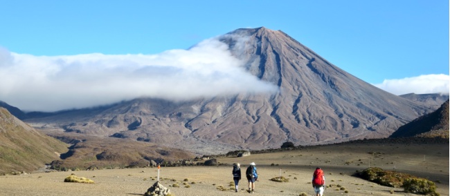
Walkers enjoying the barren lands of the Tongariro Alpine Crossing | David Tip
Blog home / Tongariro Alpine Crossing: The Complete Guide
Everything you need to know about the Tongariro Alpine Crossing
Listed as one of New Zealand's Great Walks and most popular day hikes - this 19.4km mountain adventure, journeys through ever-changing alpine terrain and jaw-dropping, out-of-this-world landscapes.
Tongariro National Park is full of ancient lava flows, glacial valleys and vivid crater lakes and is home to three active volcanic mountains. Although these volcanoes are still considered active, Ruapehu last erupted in 1996 and Ngaurhoe last erupted in 1975 making it quite safe and popular during the summer months.
There are two ways to experience the Tongariro Alpine Crossing:
Here is everything you need to know about trekking the Tongariro Alpine Crossing.
Quicklinks
Highlights
Hazards to be mindful of
Highlights on your walk
Tongariro National Park was New Zealand's first National Park and now holds a UNESCO dual world heritage status. As the volcanoes are still considered live there are active steam vents beside the track which is incredible to witness but must be treated with caution. It is important to not stray from the track for your own safety.
After climbing nearly 800m in altitude to the top of Red Crater, you'll be welcomed with out-of-this-world views of the valley below and a first glimpse of Blue and Emerald Lakes. Each lake is uniquely magnificent in colour due to the volcanic minerals dissolved in the water.
Map of Tongariro Alpine Crossing
Distance and Check Points
The 19.4km track takes on average seven to nine hours to complete.
Start of track to Soda Springs - 1 - 1.5 hours
Soda Springs to South Crater - approx 1 hour
South Crater to Red Crater - approx 1 hour
Red Crater to Blue Lake - 30 minutes
Blue Lake to Track End - 3 hours
How challenging is the track?
You don't need to be an athlete to trek the Tongariro Alpine Crossing but the difficulty of this hike can be easily underestimated. During the 19.4km hike, you'll be climbing nearly 800m in altitude or 1900m above sea level and many sections require hiking down steep and loose, rocky terrain. This is why we have graded this hike a Level 6: Moderate to Challenging.
How fit do I have to be?
We have graded our Tongariro trips a level 6: Moderate to Challenging. The emphasis is on moderate activity with several challenging stages. You will need a good level of fitness, must be in good health and you should prepare for potential variable weather conditions.
We recommend one hour of aerobic type exercise, four times a week. Hill walking with a pack in variable weather conditions is also recommended.
How to prepare for the hike
Watch this video to help prepare for your trek.
Weather & Seasons
The best time of year to complete the Tongariro Alpine Crossing Hike is between October and April, during New Zealand's tramping/hiking season. Even with pleasant weather, the alpine environment can be unpredictable.
Throughout spring and summer, you may be exposed to the harsh sun, so sun protection is required whilst bad weather may include heavy rain, strong winds, snow or freezing temperatures.
During winter to early spring, between May to October, the mountain is usually covered in snow and ice so advanced winter tramping skills are essential.
What not to wear:
Too often than not we see those about to do the Tongariro Crossing board the transfer vehicles ready to trek with sneakers or open sandals on. A t-shirt with no jacket in sight - and some with a tiny backpack that would fit not much more than a scarf. The Tongariro Alpine Crossing is one of the hardest day hikes - and all hikers should have good hiking boots with ankle support, gear for all weather conditions - including rain jackets, polar fleece etc as the wind at the top can turn a blue sky day to blizzard conditions within minutes, ensure you have enough water and other essentials such as sunscreen, hats and blister protection for the feet and plenty of snacks/lunch as you have many hours out on the trail and no cafes in sight.
Toilets along the track
There are toilets in the following locations along the Tongariro Crossing:
Mangatepopo Carpark
Mangatepopo Hut
Bottom and top of Devil's Staircase
Blue Lake
Ketetahi Shelter
Ketetahi Bushline
Ketetahi Carpark
> Read what hazards to be mindful of when trekking this Great Walk.
Tongariro Self-Guided Hikes
>> Tongariro Alpine Crossing Self-Guided Hike
>> Tongariro Northern Circuit Self-Guided Hike
------------------------------
For a checklist of what to bring and track alerts, visit Plan my Walk.
Credit: NZ Mountain Safety Council